- Trekking
- Expedition in Nepal
- Inbound Tours
- Outbound Tours
- About Us
- Contact us
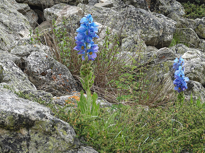
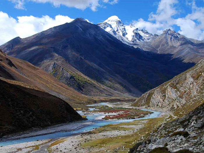
The Simikot Limi Valley Trek stands out as one of the most breathtaking and thrilling hiking routes located in the far northwestern region of Nepal. This area boasts an abundance of picturesque landscapes, lush vegetation, and diverse wildlife. The trek through Limi Valley offers unparalleled views of snow-covered mountains, an immersion into local cultures, lifestyles and traditions. Additionally, it presents a unique opportunity to explore the origin point of Nepal’s longest river, the Karnali.
The Limi Valley is inhabited by people of Tibetan descent. The ethnic group of this valley have maintain their own distinct language, traditions, and culture deeply rooted in Tibetan heritage. Often referred to as “Shangri-la” due to its remote and idyllic nature. This valley takes you through dense evergreen forests in the Karnali gorge. Where the rare and endangered species of animals and vegetation have made there home. The Simikot Limi Valley Trek treats you to breathtaking vistas of majestic mountains. Those mountain are Mt. Saipal (7031m), Mt. Byas Rishi, Mt. Api, Mt. Gorkha, Mt. Kanjirowa, Mt. Kailash, and Mt. Kanti, among others.
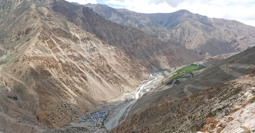
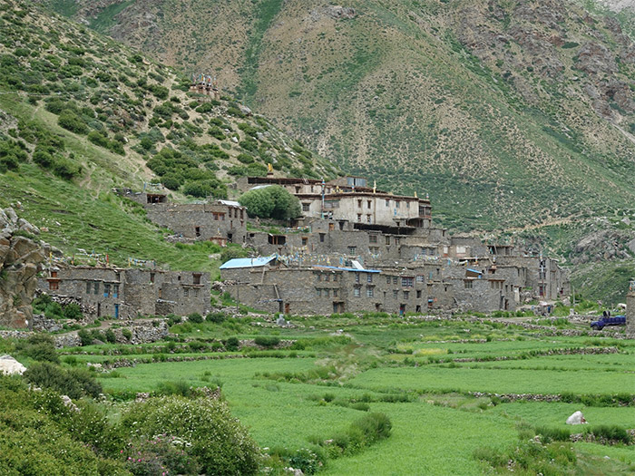
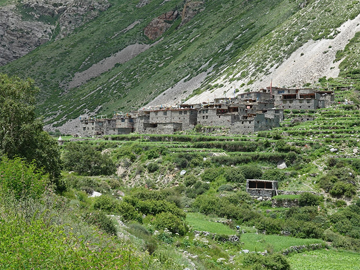
This valley is so isolated that modern amenities are practically non-existent. The local inhabitants, particularly in villages likes Til and Halji, are mostly dependent upon livestock. Their daily routine involves grazing animals on the plateau, and some are engaged in trade. Despite being the district headquarters of Humla, the valley remains remote due to its geographical seclusion.
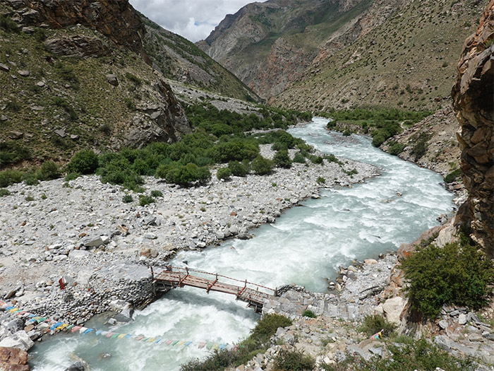
To embark on this trek, you’ll first take a flight from Kathmandu to Nepalgunj and then to Simikot. The trek begins along the banks of the Karnali River, leading you through authentic Tibetan settlements and Yak Pastures. Along the way, you’ll traverse an isolated high-altitude landscape, including a crossing of the Nara La pass at an impressive altitude of 4,560 meters, before reaching the Tibetan border at Hilsa. From Hilsa you can see Holy Mt. Kailash of Tibet. We then complete a loop through Tiljung, Halji, and Limi, including crossing the high point Nyalu La (5,001m). After that we return back to Simikot. Throughout the trek, camping arrangements are necessary since local teahouses have not yet been adequately developed.
The Simikot Limi Valley Trek is a highly recommended for those who are seeking solitude in the wilderness and are prepared to navigate the logistical challenges of the region to experience the lives of remote rural mountain villages in Nepal.
Upon your arrival in Kathmandu, you will be greeted at the airport and transferred to your hotel. Later in the evening, we will have a pre-departure meeting regarding the details of your trip.
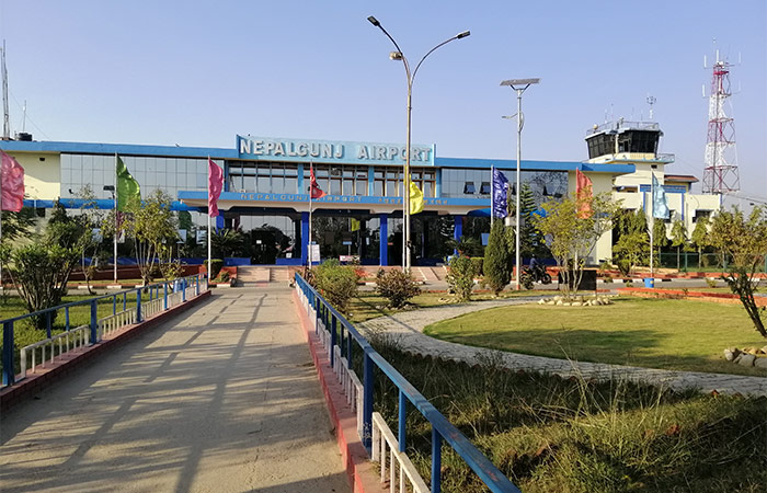
In the morning, we will arrange for your pickup from your hotel and then transfer you to the airport for a scenic flight to Nepalgunj in Western Nepal. The flight, which lasts approximately 45 to 50 minutes, will take us near the Nepal-India border.
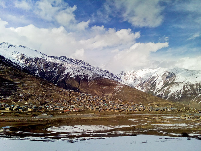
Boarding on a scenic 45-minute flight from Nepalgunj, you’ll experience the exhilaration of soaring over picturesque valleys and landscapes, eventually arriving at the stunning destination of Simikot. Upon landing at Simikot, which serves as Administrative Headquater of Humla district, we will take the opportunity to explore the charming streets of this small hill town. Additionally, we will have the chance to meet with the remaining members of our crew who will be accompanying us on this journey.
We embark on the first day of our trek on The Great Himalaya Trail High Route from Simikot. As we leave Simikot, we set foot on a descending trail leading us Humla Karnali River. Along the way, we traversed through a pine forest, grove of walnut trees, passed by several quaint villages, and crossed suspension bridges before finally reaching Dharapuri.
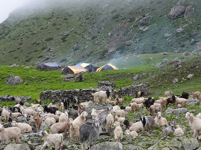
After breakfast, we take the left trail at the junction near Dharapuri village, leading to a gorge in the Humla Karnali valley with Chaya Chahara waterfalls, a popular lunch spot. Afterward, hike to Dhar Kermi and then Sangrak Kermi, where you’ll find suitable campsites and a hot spring. In Humla, lower regions are inhabited by various ethnic groups, while higher areas are home to people of Tibetan descent. They practice polyandry and engage in trade, with distinct festivals like Losar and Saga Dawa. Rimche, a key village festival, celebrates Buddhism’s triumph over minor faiths with lama dancing.
We begin our hike with an easy ascent to Okharthala. Then we hike through a patchy pine forest until you reach Salli Kadh, a minor pass adorned with prayer flags, offering views back down the valley. We then descend to Salli Khola, where we’ll cross a suspension bridge to a flat area which is perfect for lunch. Continuing on the trail we reach a spacious flat area near the river, often used by mule caravans before climbing gradually to Taplung (Yulwang), a scattered village on a south-facing hillside. On the far side of the village, you’ll find a Namkha Khyung Dzong gompa and school where we can camp.
The trail winds around a rocky ridge before descending to Yalbang village, a picturesque Buddhist settlement at the entrance to another gorge along the Humla Karnali river. Occasional mountain views appear as the path navigates rocky terrain. We cross a wooden bridge to the south bank, and then climb gently to Muchu village, where the valley widens. We continue to Chhuigaon village and then descend to Tumkot Khola, where we set up our camp. Later in the evening, we can visit Mota gompa situated on the hill.
From the campsite’s end, the trail enters a narrow gorge and ascends switchbacks to reach a minor pass known as Pathalna, marked by a cairn and prayer flags. Beyond this pass, the terrain becomes easier as you continue along the under-construction road to Pani Palbang. We can see how the landscape has changed, becoming barren and stony. Following Pani Palbang, there’s a gradual climb pass Yari East and Yari West to reach the Yari valley.
The trail descends a bit from Yari village, then gradually ascends to Jogi Odar, where there are tent platforms and teashops. Afterward, it steepens through Shiv Shiv valley, leading to Nara La at 4,620m. Top of Nara La will greet us with fluttering colorful prayer flags and spectacular views of Saipal Himal and Holy Mount Kailash (6,638m) in Tibet. We then descend along the barren rocky trail to reach Hilsa (Yulsa), a small town bordering Tibet.
Leaving Hilsa behind, we cross the suspension bridge over Humla Karnali River, and ascend the scree slope to reach the primary trail from Taklakot to Halji. Once on the main trail, turn right (east) and continue to ascend more gradually to a high point marked by prayer flags. From there, the trail encounter a brief descent with switchbacks through amazing sceneries of barren peaks and small bushes, leading you to the campsite at Manepeme, named after a large rock carved with the Buddhist mantra, Om Mani Padme Hum.
Take your time on the easy trail, and watch for Himalayan Griffon and Lammergeyer. After about an hour, you’ll begin a climb with great views on a donkey trail with switchbacks and a less exposed “human” trail. We have a lunch break at Chay Gompa, a hermitage with frescoes. After lunch, we continue to Jhonbo La pass (4230m) and then join the main trail of Limi Valley Trek. We descend with views of the Til valley and reach Tiljung at the confluence of Til Khola and Limi Khola. Til is the first village in Limi Valley and has sacred Ya Yip Phuk cave and 300 years old Kunzum Do-Nag monastery.
It’s an easy day’s walk to Halji, where you can explore ancient monasteries. We cross the bridge upstream from the campsite on the true left (south) bank of the Limi Khola and follow a easy trail to reach Halji village on the true right (north) bank of the Limi Khola. We will explore 800 years old Rincheling Gompa which houses ancient statues, large prayer wheels and many masks for the Rimche Festival.
Leaving Halji behind, our trail goes up a rocky valley along the bank of Limi River passing grazing areas and reaching Sunkarni which has new police post. Then, continue through a craggy canyon to Dzang (Jang), which houses a large ancient monastery. After the village, we climb alongside Takchhe Khola to a new road construction site and a small hot spring at 4063m. We then follow the impressive flat-bottomed valley to reach Tholing.
The valley widens before Takchhe, where there’s a hot spring by the river. This area has abandoned buildings from the region’s first settlement. To the south, you’ll find a massive sand dune leading to a shallow lake. If the lake is low, head straight to a trail above the eastern shoreline; otherwise, take a longer route around boggy ground. The trail follows the lake’s edge and descends to scattered kharka at the lake’s far end. Further ahead, the Talun Khola valley rises in moraine steps, created by long gone glaciers. After easy climbs to flat sections of the valley, you’ll see rocks marked as Limi Campsite.
We begin our tough day early with a short walk to the base of a series of switchbacks leading to a cairn with great views of Talun valley and Lubuchela Himal. Then, ease through moraine to reach the final climb to Nyalu La at 5,001m. Nyalu La, the highest point of the trek offers a breathtaking view of Holy Mount Kailash and other snow-capped mountains as well as the scenery of Tibet and Humla. After glorious moment, we descend steeply to Selima Daha, a turquoise lake. After a steep, rocky descent, you’ll reach a flat valley, a potential campsite with excellent views of Saipal Himal if you decide to stay here instead of continuing down the valley.
After breakfast, we walk along a section of road on the true left side of the valley floor, then descend through birch and pine forest with occasional steeper sections and views of Saipal Himal to the south. We descend alongside Salli Khola, cross a wooden bridge to the true right bank, climb to the Salli Khad pass (3144m), and rejoin the main trail to Simikot. Finally an easy descend along the Humla Karnali River brings us to our campsites at Sangrak (Kermi). In the evening you can take a dip in the natural hot spring to soothe your aching muscles.
Today is our final day of trekking. We leave Kermi and follow the familiar trail, passing through charming villages and traverse landscapes that have become part of our journey’s tapestry as we make our way back to Simikot.
Bidding farewell to the remote Limi Valley, we board on a flight from Simikot to Nepalgunj and then connecting flight from Nepalgunj to Kathmandu.
Upon arrival in Kathmandu, we will drop you at your respective hotel where you can reflect on the incredible journey we’ve undertaken, the challenges we’ve overcome, and the bonds we’ve formed with fellow trekkers. We will have a sense of accomplishment and gratitude, knowing that this adventure has left an indelible mark on our hearts and souls.
No related packages available.